Pülnhof
Facts:
- Town:
- Unterbergern
- subsite of:
- Donauleiten
- Size in ha:
- 4,77
- Altitude in m:
- 310 - 354
- Aspect:
- S - SO
- Average Slope in %:
- 15
- Labour required in h:
- 1.700
- First documentary evidence:
- JF 1786 - 1787
Description
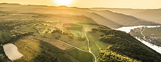
Pülnhof is the name given to the western reaches of the Donauleiten vineyard. The name goes back to the nearby St. Pöltner Hof.
Soil Profile Pülnhof
In the Wachau, metamorphic rock is also found on the right bank of the Danube. Gföhl gneiss appears in the Pülnhof section of the Donauleiten vineyard in Unterbergern, a municipality actually belonging to Dunkelsteinerwald. In contrast to the steep slopes of the Danube valley and Spitzer Graben, gentle hills leading up to a plateau are characteristic of the landscape. Shallow and meagre soils can nonetheless be found on the upper slopes, as the profile from Unterbergern shows. The topsoil, typically silty and sandy and rich in humus, still resembles the former loess cover, now decalcified. Weathered Gföhl gneiss dominates beginning at a depth of 35 cm. Here, unlike in areas of the Danube Valley, the fissures in the rock do not display any secondary carbonate precipitates from the former loess cover.