Donauleiten
Facts:
- Town:
- Unterbergern
- Altitude in m:
- 244 - 354
- Aspect:
- N - E
- Average Slope in %:
- 14
- Max. Slope in %:
- 77
- Terraced vineyard:
- No
- Distance to Danube in m:
- 479
- First documentary evidence:
- MTF (1751 - 1753)

Description
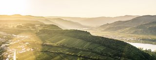
As already suggested by the name (Leiten = rising ridge), Donauleiten designates a vineyard on the slope facing the Danube. Together with the Galiziberg section, it stretches in an arc around the forest above Unterbergern, going down towards the Danube. This vineyard is divided into two parts by the municipal boundary between Mautern and Unterbergern.
Soil Profile Donauleiten
Like the Pülnhof section, in particular the northwestern parts of the Donauleiten vineyard, also in Unterbergern, are dominated by Gföhl gneiss. The vines in the southwestern portion, on the other hand, are rooted in glacial loess.
The vertical layers of rock favour the penetration of rainwater, which in turn causes subsoil weathering down to an extensive depth. As a result, the vine roots can penetrate through the fissures and deeply into the rock packages. The light-coloured vertical stripes on the profile represent very hard quartz that is resistant to weathering. As it weathers, rock rich in quartz gives way to sandy, meagre soils.