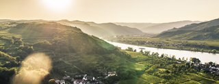
Donauleiten
Facts:
- Town:
- Mauternbach
- Size in ha:
- 8,97
- Altitude in m:
- 199 - 283
- Aspect:
- N - NO
- Average Slope in %:
- 20
- Max. Slope in %:
- 69
- Distance to Danube in m:
- 20
- Labour required in h:
- 13800
- First documentary evidence:
- 1453
Description
As already suggested by the name (Leiten = rising ridge), Donauleiten designates a vineyard on the slope facing the Danube. Together with the Galiziberg section, it stretches in an arc around the forest above Unterbergern, going down towards the Danube. This vineyard is divided into two parts by the municipal boundary between Mautern and Unterbergern.